
By 2026, a national project aims to map the entire French territory in three dimensions. The National Institute of Geographic and Forestry Information (IGN) is behind this "project", entitled "Lidar HD", whose objective is to obtain a very precise 3D description of the territory. In the long term, the map could analyse and influence economic development or public policies for land use planning, but also prevent geological risks.
A national program to map the French territory digitally and in three dimensions
The national Lidar HD (for "High Density") program is a project that will see the French territory mapped in 3D. For five years, with a budget of 60 million euros and a large number of partnerships, the IGN will be at the helm of this initiative, which will require 7,000 hours of flying. The program benefits from significant support from the State and relies on the consortia selected in 2020 via the framework agreement on aerial photography and Lidar: Avineon/APEI, Geofit/Geofly, Eurosense/SFS and Sintegra/Pixair/BlueSky.Lidar allows the production of dense and precise 3D maps, which are essential for a detailed knowledge of the territory (ground, on the ground) and for monitoring its evolution. This distance measurement technique uses the properties of light: a scanner on board an aircraft emits very high frequency light pulses (in the near infrared range) towards the ground. The Lidar detects the reflected waves, records their travel time and deduces the position of the impacted points.
Future mapping will meet the needs of observation and analysis in many fields:
- Prevention of natural risks.
- Knowledge of the forestry resource.
- Monitoring of the common agricultural policy.
- Energy transition and sustainable urban development.
- Regional planning.
- Internal security.
- Revealing archaeological remains.
Half of the territory mapped by 2022, the rest by 2026
The IGN specifies all the actions that their teams will carry out in order to make this 3D map of France:"By providing classified Lidar point clouds, digital terrain models (DTMs) and digital surface models (DSMs), the Lidar HD programme will enable France to move from a progressive coverage of the territory with an average point cloud density of 2 points per square metre, to a coverage of 10 points per square metre on average over the whole of metropolitan France and the overseas departments, except for French Guiana, which will be the subject of specific measurements.Below, find the map of the status of the acquisition project:The production site promises to be titanic. With current technologies, the project requires nearly 7,000 hours of flight time. The data produced will represent a total volume of 3 petabytes (or 3 million gigabytes). They will gradually be released as open data.
"
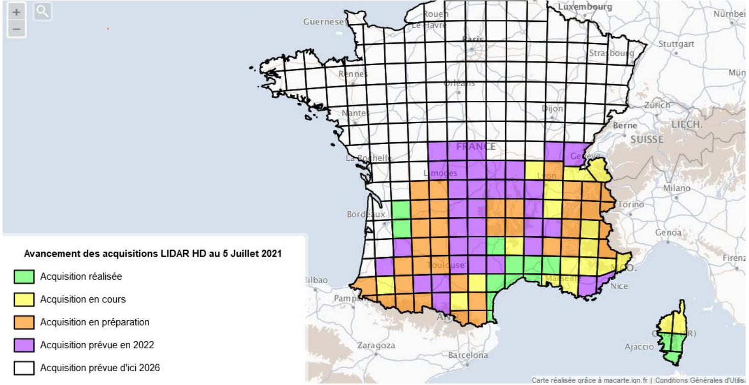
As can be noticed, the road is still long since by 2022, only 40% of the French territory (the southern half) will have undergone all of the acquisition work necessary for the realization of 3D mapping. At present, only South Corsica, the Languedoc coastline and part of the Gironde and Dordogne regions have already been fully acquired.
Translated from Le programme national Lidar HD : la cartographie 3D de l'ensemble du territoire français